Mark Slavonia | January 25, 2022
The 5G Interference Edition
On data, networks, and reliability
Mark Slavonia (MJS) is an investor, a pilot, and an avid cyclist. He wrote about kitchen ballet, rowing machines, traveler’s checks, and more. He posts other things that are interesting on his website and on Twitter.
Mark here. The rollout of 5G data networks is exposing a conflict between the Federal Communications Commission (FCC), which auctioned the rights to use the radio frequencies on which 5G networks operate, and the Federal Aviation Administration (FAA), which has for decades governed the use of similar radio frequencies that are used to help guide airplanes. The FAA, pilots, and airlines object to the rollout of 5G cellular networks near commercial airports due to concerns that the 5G signals may interfere with the navigation systems of planes. Even accommodating the possibility that 5G signals might interfere with navigation could cause diversions and delays.
The FAA’s concern with 5G relates to devices called radar altimeters. Radar altimeters are highly accurate altitude-measuring devices that are carried in commercial aircraft. Unlike normal barometric (air pressure) altimeters which are used in regular flight, radar altimeters have a highly specialized purpose. They are used to help land planes in terrible weather.
Why is this interesting?
Pilots landing in poor weather rely on standardized single-page charts, called approach plates, that contain the information needed to land safely and the procedures to be followed if a landing has to be aborted. Pilots train to be able to read, interpret, and follow these plates during flight, since runway assignments, directions, and even destinations may need to be adjusted in times of severe weather.
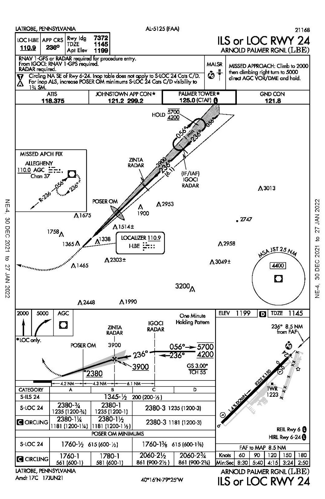
In moderately bad weather, pilots can use GPS or follow a ground-based radio beacon that gives horizontal and vertical guidance (basically, this is like following a guidance beam projected along the proper flight path). These standard instrument approaches generally work as long as the lowest layer of clouds is at least 200 feet above the runway and the visibility at the ground is about half a mile.
But when making landings in the worst weather—when pilots may not be able to see the runway even when they’re just a few feet above it—a more accurate altitude measurement is necessary in addition to the guidance given by GPS and radio beacons. Radar altimeters fill this need.
A radar altimeter aims a signal down to the ground and measures the time that it takes for that signal to bounce back to the plane. Radar altimeter systems can then convert that time into an accurate measurement of the plane’s altitude above ground at that moment. This specialized type of radar points only in one direction (down), is looking for only one thing (the ground), and yields only one output (distance).
Radar altimeters are integrated into the plane’s operation in complicated ways. Many will trigger an audio signal at predetermined altitudes. Some integrate with a virtual display of a digital runway. And some integrate directly with the autopilot systems in aircraft that have automatic landing capability. Automatic landing capability is required for landings when the runway is not visible at any altitude.
Not surprisingly, aviation requires very high levels of reliability—there isn't any room for "we're pretty sure this will work". If your radar altimeter isn't working when you're making a landing in zero visibility you've got a big problem. It's even worse if you think it's working but it's giving readouts that are even slightly wrong. Without reliable radar altimeters, pilots would be limited to making landings when the lowest clouds were at least 200 feet above the runway, using radio beacon and GPS systems. This would result in more frequent diversions and delays.1
Radar altimeters operate on frequencies similar to those used in 5G data systems. While these altimeters are reliable and highly regulated, many are based on older technology that was not designed to account for and filter out signals that are on similar frequencies. The FAA is claiming that the FCC didn’t give adequate notice to allow for testing radar altimeters for possible 5G interference or for the development of replacement or upgraded radar altimeters with better signal filtering. It seems likely that any conflicts between radar altimeters and the 5G network can be fixed by upgrading the radar altimeters, but that would take some time and planning to roll out across the airlines’ fleets.
I don't know enough about the spectrum frequencies, power, and potential for error to evaluate the true risk that the 5G system would cause. The FAA is arguing that, essentially, the FCC doesn’t know enough either. (MJS)
Quick Links:
James Fallows wrote an excellent Q&A about the conflict between airlines and 5G. (MJS)
Patrick Smith, an airline pilot, and author, describes the problem on his askthepilot.com website (MJS)
Peter Coy’s opinion piece in the New York Times discusses the lack of coordination between the FAA and the FCC (MJS)
--
WITI x McKinsey:
An ongoing partnership where we highlight interesting McKinsey research, writing, and data.

The kids are not all right: Dr. Kevin Churchwell, president and CEO of Boston Children’s Hospital, says there’s been a sharp rise in behavioral and mental-health issues among children and young adults. What’s causing this escalation? How can families, hospitals, schools, and the healthcare system work together to tackle these issues? Don’t miss this interview with Dr. Churchwell.
--
Thanks for reading,
Noah (NRB) & Colin (CJN) & Mark (MJS)
—
Why is this interesting? is a daily email from Noah Brier & Colin Nagy (and friends!) about interesting things. If you’ve enjoyed this edition, please consider forwarding it to a friend. If you’re reading it for the first time, consider subscribing (it’s free!).
Estimating how much more frequent is hard to say as it’s super specific to locations. I read two A320 pilots who said that they made only about one full-autoland landings every year. But the delays and disruptions ripple out because airlines would have to cancel flights when low visibility was even just a possibility.